Terrestrial and Air Temperatures and Light Levels at Rosario |
||
| Data: | Details | |
| Rosario summer light/temperatures terrestrial | Measurement of temperature (Deg C) and light (lux) levels on the roof of the Beach Lab at Rosario, which is right next to the beach. Dates July 19-August 16, 2024. Hobo Light/temperature logging pendant sensor serial #20160551 was strapped to a brick set on the roof. The sensor is in full sun. | |
| Dates August 16 to Sept 15 2024 | ||
;
Subsurface Seawater Temperatures in Rosario Bay: |
||
| Data: | Details | |
| Rosario Bay Seawater Temperature 2003-2005: At Northwest Island | An Excel .xlsx file of about 16,450 hourly seawater temperature records taken in Rosario Bay at a depth of approximately 10 m on the southeast (Rosario Bay) side of Northwest Island. Data were collected hourly by a Hobo Water Temp Pro or Water Temp Pro v2 data logger from August 12, 2003 to June 28, 2005. Location approximately 48.4187 N, 122.6701 W | |
| Rosario Bay Seawater Temperature Dec 2013-March 2014 at RBML Seawater Intake | An Excel .xlsx file of about 672 seawater temperature records taken at 3-hour intervals in Rosario Bay at a depth of approximately 4-5 m at the base of the Rosario Beach Marine Laboratory seawater intake frame. Data were collected hourly by a Hobo Water Temp Pro or Water Temp Pro v2 data logger from December 30, 2013-March 24, 2014. Location approximately 48.4191 N, 122.6653 W | |
| Rosario Bay Seawater Temperature 2024-07-03 to 2024-08-18 | An Excel .xlsx file of 1105 hourly temperature records taken by a Hobo Water Temp Pro v2 data logger from July 3 to August 18, 2024 at the Rosario seawater intake frame. Temperatures ranged from 10.4 to14.1 C, but were mainly between 11 and 12 C. | |
Intertidal Temperatures at Sares Head, Rosario Bay.Intertidal rock surface temperatures were recorded at various intertidal heights and orientations. At Rosario Bay mean high tide is +7.0 ft (+2.13 m); mean tide is +4.6 ft (1.40 m), mean low tide is +2.3 ft (0.70 m). |
||||||
Standard Mid-tidal Temperature Measurements in Setup Compatible with CCTBON System: 3 mid-tide sensors on vertical surface facing north, and 3 mid-tide sensors on vertical surface facing south. |
||||||
| Sensor Name: SHMainN1 | Tide Height +5.4 ft
+1.64 m |
Description: North-facing ElectricBlue EnvLogger model
T7.3, serial
number 044F DF00 311B 08. Vertical orientation, north-facing. On left
back
side of tall boulder about 2/3 way out Sares Head on the north shore of
Rosario Bay.
48.42044 N 122.66772 W. UTM 10 524585 5363085. Installed 7-7-2024 |
Photos | |||
| Date range: July 7-Aug 16, 2024 | ||||||
| Date range: August 16-October 1, 2024 (Every 30 seconds) | ||||||
| Date range: | ||||||
| SHMainN2 | Tide Height +5.4 ft
+1.65 m |
Description: North-facing ElectricBlue EnvLogger model
T7.3, serial
number 041C A100 EE5A 07. Vertical orientation, north-facing. On
middle-right
back side of tall boulder about 2/3 way out Sares Head on the north
shore
of Rosario Bay.
48.42042 N 122.66774 W. UTM 10 524583 5363083. Installed 7-7-2024 |
Photos | |||
| Date range: July 7-Aug 16, 2024 | ||||||
| Date range: July 7, 2024-July 14, 2025 | Details: | |||||
| Date range: | ||||||
| SHMainN3 | Tide Height +5.5 ft
+1.67 m |
Description: North-facing ElectricBlue EnvLogger model
T7.3, serial
number 04DC D900 9022 0C. Vertical orientation, north-facing. On right
back side of tall boulder about 2/3 way out Sares Head on the north
shore
of Rosario Bay.
48.42042 N 122.66775 W. UTM 10 524582 5363083. Installed 7-7-2024 |
Photos | |||
| Date range: July 7-Aug 16, 2024 | ||||||
| Date range: August 16-October 1, 2024 | Details: | |||||
| Date range: | ||||||
| SHMainS1 | Tide Height +4.5 ft
+1.36 m |
Description: South-facing ElectricBlue EnvLogger model
T7.3, serial
number 0408 7400 473E 06. Vertical orientation, south and ocean-facing.
On right exposed side of boulder about 1/2 way out Sares Head
on
the north shore of Rosario Bay; just to the right (east) of a boulder
cave
when viewed from the ocean.
48.42032 N 122.66795 W. UTM 10 524568 5363072. Installed 7-7-2024 |
Photos | |||
| Date range: July 7-Aug 16, 2024 | ||||||
| Date range: July 7, 2024-July 13, 2025 | Details: | |||||
| Date range: | ||||||
| SHMainS2 | Tide Height +4.4 ft
+1.35 m |
Description: South-facing ElectricBlue EnvLogger model
T7.3, serial
number 0405 0D00 442E 04. Vertical orientation, south and ocean-facing.
On left exposed side of boulder about 1/2 way out Sares Head
on the
north shore of Rosario Bay; 2nd boulder to the right (east) of the
boulder
cave when viewed from the ocean.
48.42036 N 122.66693 W. UTM 10 524643 536077. Installed 7-7-2024 |
Photos | |||
| Date Range: July 7-Aug 16, 2024 | ||||||
| Date range: July 7, 2024-July 14, 2025 | Details: | |||||
| Date range: | ||||||
| SHMainS3 | Tide Height +4.5 ft
+1.37 m |
Description: South-facing ElectricBlue EnvLogger model
T7.3, serial
number 0452 6300 6D17 0D. Vertical orientation, south and ocean-facing.
On right exposed side of boulder about 1/2 way out Sares Head
on
the north shore of Rosario Bay; 2nd boulder to the right (east) of the
boulder cave when viewed from the ocean.
48.42035 N 122.66693 W. UTM 10 524643 5363076. Installed 7-7-2024 |
Photos | |||
| Date range: July 7-Aug 16, 2024 | ||||||
| Date range: July 7, 2024-July 14, 2025 | ||||||
| Date range: | ||||||
Other Intertidal Measurement Sensors:These sensors are also ElectricBlue EnvLogger model T7.3, but placed in different positions and orientations than the standard CCTBON positions above, such as high or low intertidal on horizontal surfaces on top of rocks (in order from highest to lowest), or in an intertidal cave. |
||||||
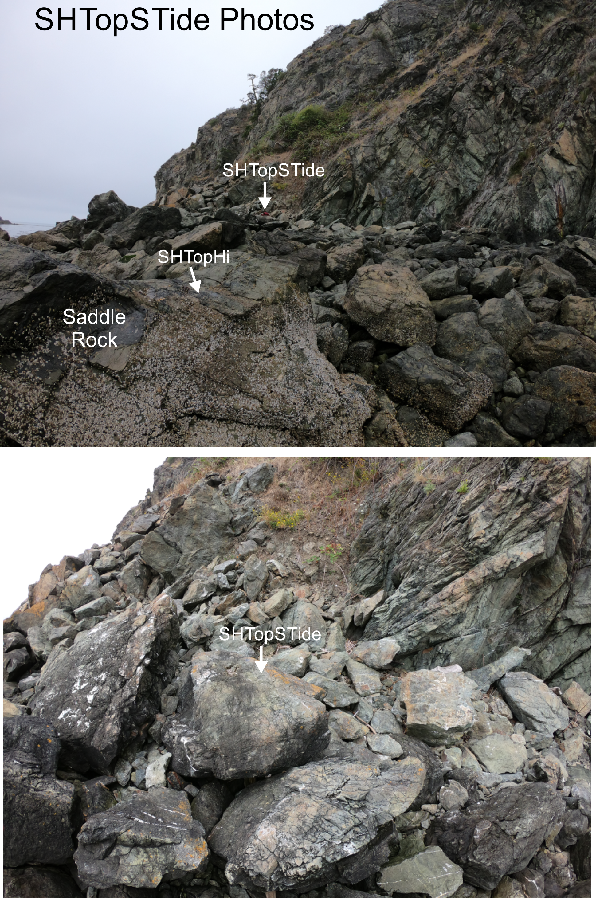
| SHTopSTide | Tide Height +11.1 ft
+3.38 m |
Description: ElectricBlue EnvLogger model T7.3, serial
number 0412
0B00 5650 0A, mounted horizontally on top of a flat-topped orange
lichen-stained
rock in the supratidal
zone
NNW of SHMainS1, at side of large boulder pile and near base of
cliff.
48.42401 N 122.66702 W. UTM 10 524635 5363482. Installed 7-19-2024 |
Photos | |||
| Date range: July 19-Aug 16, 2024 | ||||||
| Date range: July 19, 2024-July 14, 2025 | ||||||
| Date range: | ||||||
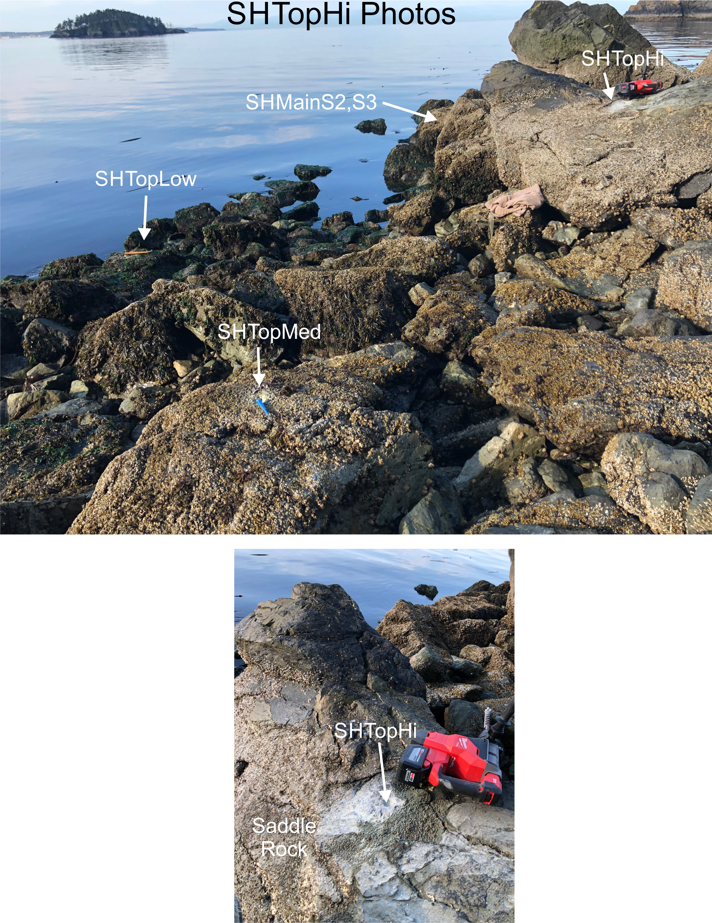
| SHTopHi | Tide Height +6.7 ft
+2.04 m |
Description: ElectricBlue EnvLogger model T7.3, serial
number 043C
4600 4021 01, mounted horizontally on the central top of a
saddle-shaped
boulder near the
top of the barnacle
zone. Boulder is directly N and above SHMainS2 &
S3.
48.42034 N 122.66682 W. UTM 10 524645 5363074. Installed 7-18-2024 |
Photos | |||
| Date range: July 18-Aug 16, 2024 | ||||||
| Date range: July 18, 2024-July 14, 2025 | ||||||
| Date range: | ||||||
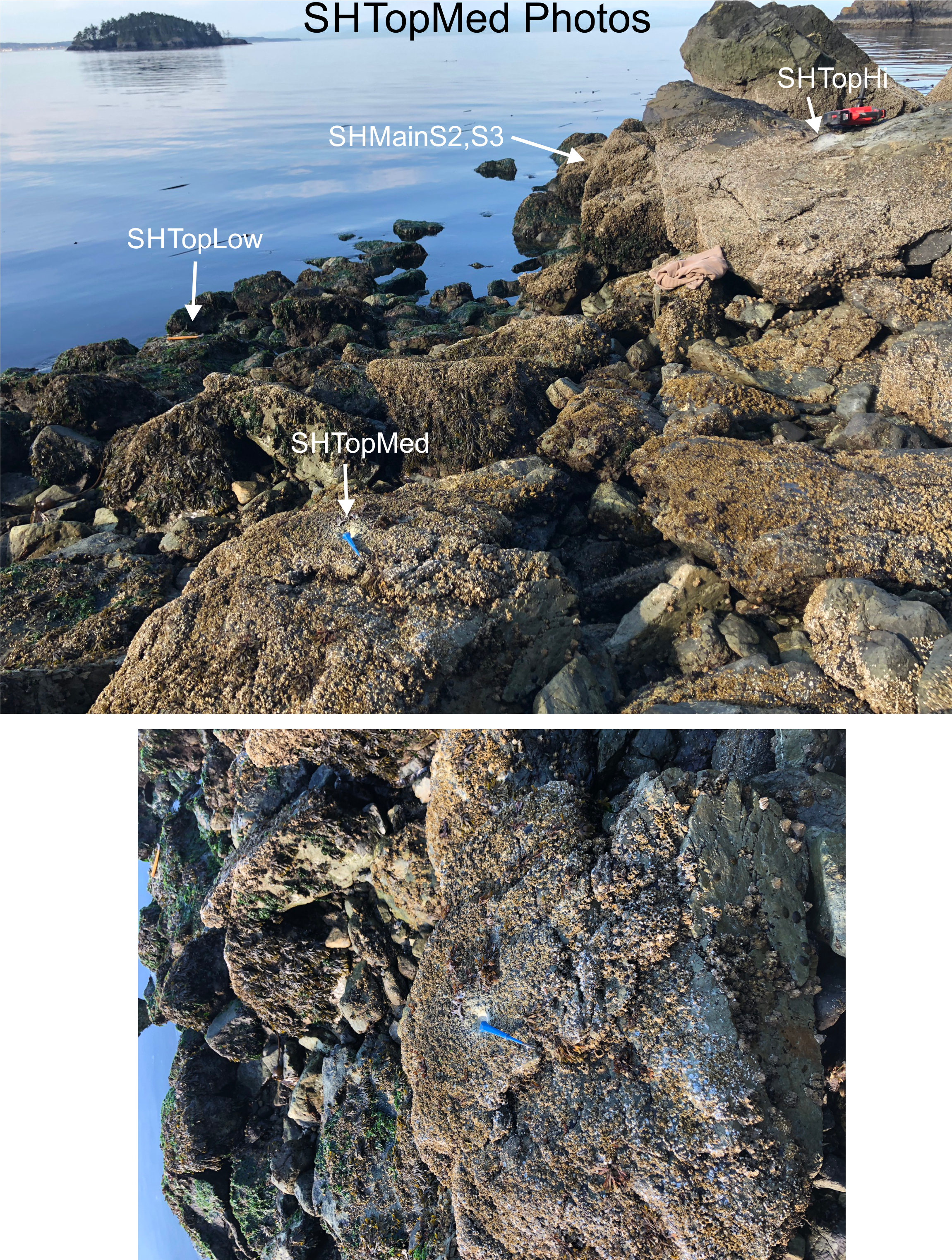
| SHTopMed | Tide Height +4.3 ft
+1.31 m |
Description: ElectricBlue EnvLogger model T7.3, serial number 04DD 2200 BA1A 01, mounted horizontally on top of a flat-topped rock near mid tide in the barnacle zone. About 8 m NE of SHMainS3. 48.42036 N 122.66684 W. UTM 10 524650 5363077. Installed 7-18-2024 | Photos | |||
| Date range: July 18-Aug 16, 2024 | ||||||
| Date range: July 18, 2024-July 14, 2025 | ||||||
| Date range: | ||||||
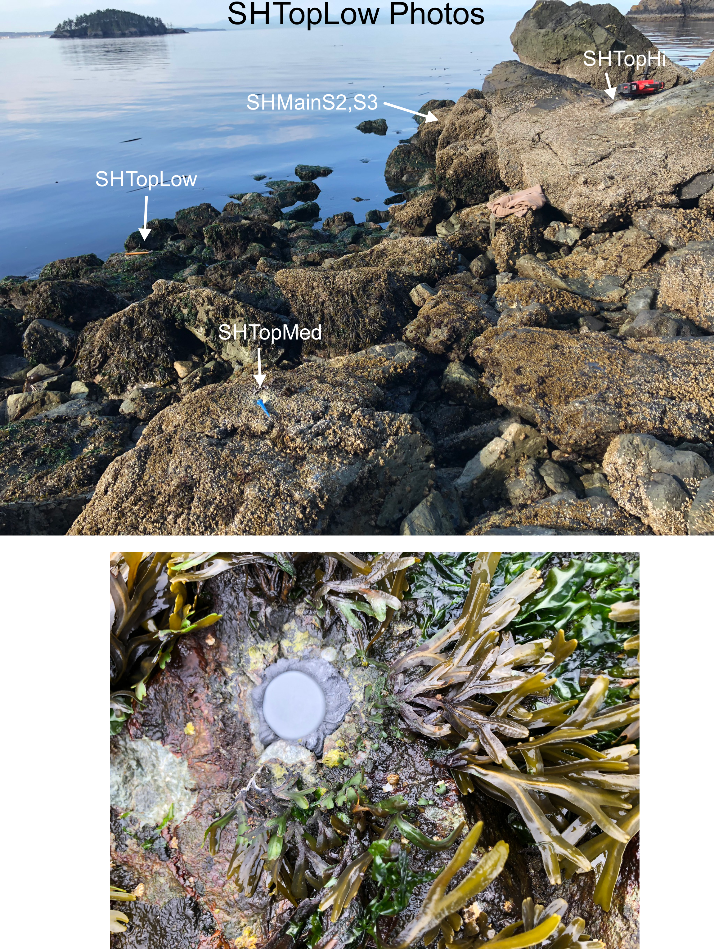
| SHTopLow | Tide Height
+0.7 ft +0.21 m |
Description: ElectricBlue EnvLogger model T7.3, serial number 04DE A300 3805 06, mounted horizontally on top of a flat-topped rock near 0 tide in the Laminarian zone. About 8 m SE of SHMainS3. 48.42029 N 122.66682 W. UTM 10 524651 5363069. Installed 7-18-2024 | Photos | |||
| Date range: July 18-Aug 16, 2024 | ||||||
| Date range: July 18, 2024-July 14, 2025 | ||||||
| Date range: | ||||||
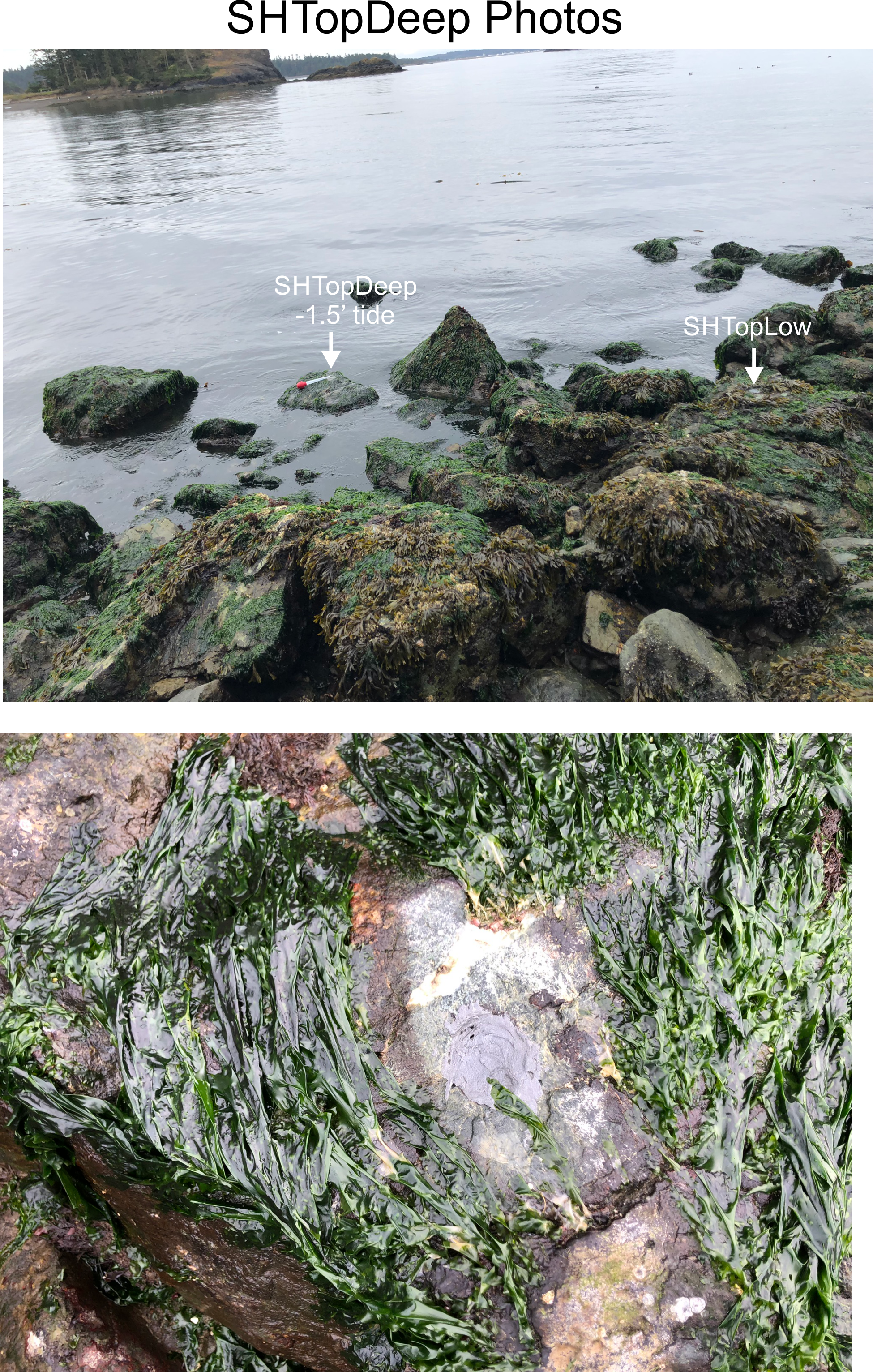
| SHTopDeep | Tide Height
-1.0 ft -0.29 m |
Description: ElectricBlue EnvLogger model T7.3, serial
number 046E
6100 5658 0F, mounted horizontally on top of a flat-topped
rock below
0 tide in the Laminarian zone. About 11 m SE of SHMainS3
and 3m
SE of SHTopLow.
48.4203 N 122.66682 W. UTM 10 524651 5363070. Installed 7-19-2024 |
Photos | |||
| Date range: July 19-Aug 16, 2024 | ||||||
| Date range: July 19, 2024-July 14, 2025 | ||||||
| Date range: | ||||||
| Date range: | ||||||
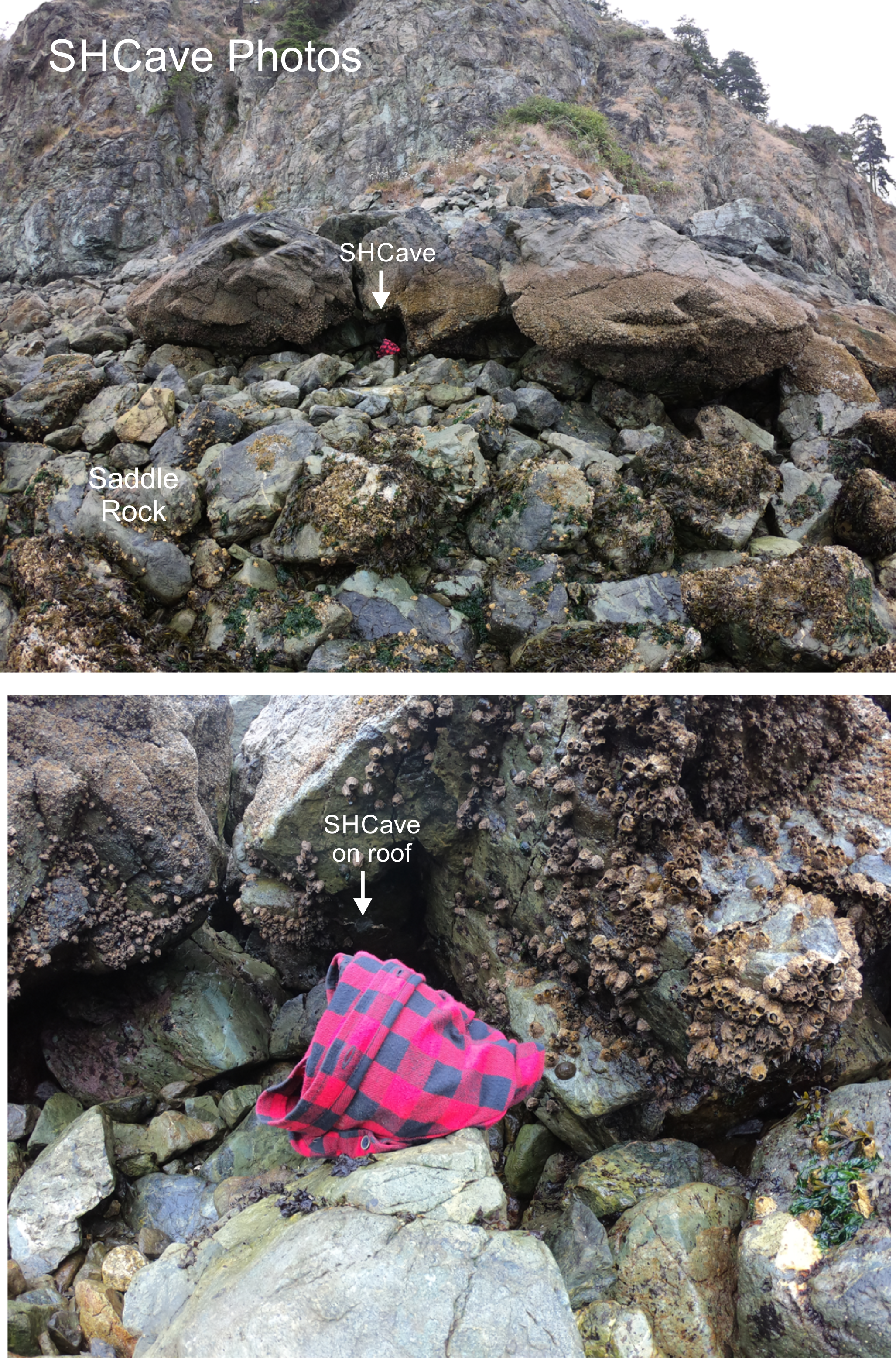
| SHCave | Tide Height +4.9 ft
+1.49 m |
Description: ElectricBlue EnvLogger model T7.3, serial
number 04BC
0900 7001 03, mounted nearly horizontally into the
roof of a boulder cave at mid-tide height to the left
(west) of
the large boulder pile, about 20 m W of SHTopHi.
48.42035 N 122.66727 W. UTM 10 524618 5363076. Installed 7-19-2024 |
Photos | |||
| Date range: July 19-Aug 16, 2024 | ||||||
| Date range: July 19, 2024-July 14, 2025 | ||||||
| Date range: | ||||||
| SH | Tide Height | Description: | ||||
| Date Range: | ||||||
| Date range: | ||||||
| SH | Tide Height | Description: | ||||
| Date range: | ||||||
| Date range: | ||||||
| SH | Tide Height | Description: | ||||
| Date range: | ||||||
| Date range: | ||||||
| SH | Tide Height | Description: | ||||
| Date range: | ||||||
| Date range: | ||||||
| SH | Tide Height | Description: | ||||
| Date range: | ||||||
| Date range: | ||||||
| SH | Tide Height | Description: | ||||
| Date range: | ||||||
| Date range: | ||||||
| SH | Tide Height | Description: | Photos | |||
| Date range: | ||||||
| Date range: | ||||||
| SH | Tide Height | Description: | Photos | |||
| Date range: | ||||||
| Date range: | ||||||
| SH | Tide Height | Description: | Photos | |||
| Date range: | ||||||
| Date range: | ||||||
| SH | Tide Height | Description: | Photos | |||
| Date range: | ||||||
| Date range: | Details: | |||||